Retford dive-under commenced construction in 1963 and was completed in 1965, and including re-signalling cost £1 million of which in 2016 prices would be £13.5m.
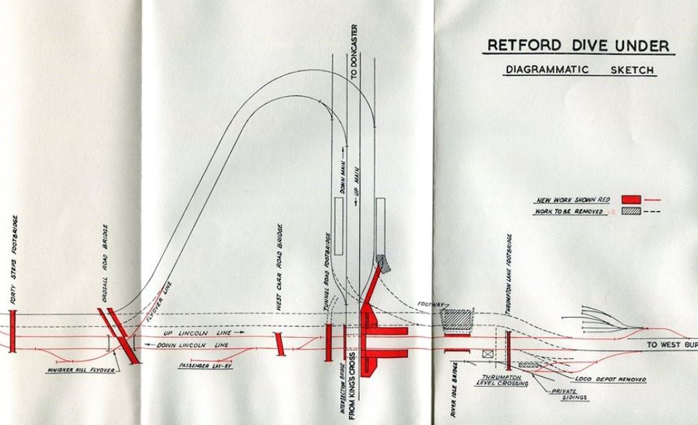
It was essential to ease rail traffic congestion due to the flat-crossing that split the LNER & the GCR (the LNER is now the ECML and the GCR is the low-level line).
The construction would see a huge amount of soil removed, over 350,000 tonnes and 26,000 tonnes of concrete used. It would also see the closure of several signalboxes; Whisker hill , Ordsall Road , Welham Road, Gringley Road, Checkerhouse and Rushey Sidings in 1965.
The area was resignalled and control transferred to Thrumpton crossing signalbox via a brand new 'NX' type panel, after the removal of Thrumpton's own lever frame. Retford South would no longer control the so-called 'ex GC' lines.
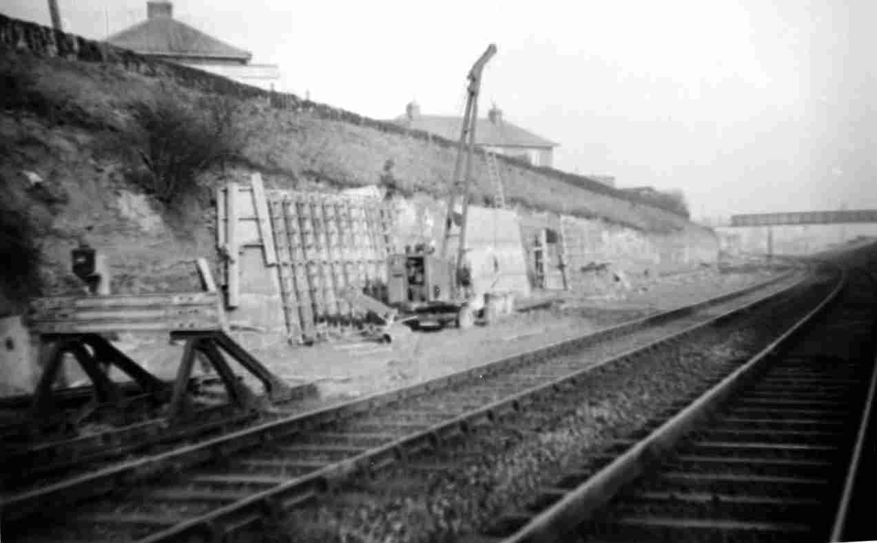
Pictured above is the construction of the retaining wall at Gringley Goods Loop, the loop however is yet to go in. The footbridge from Trent street in pictured in the foreground.
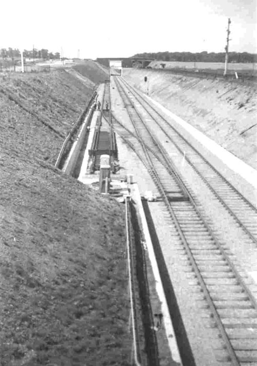
Above: West Carr road sidings go in. However this was removed at a later date.
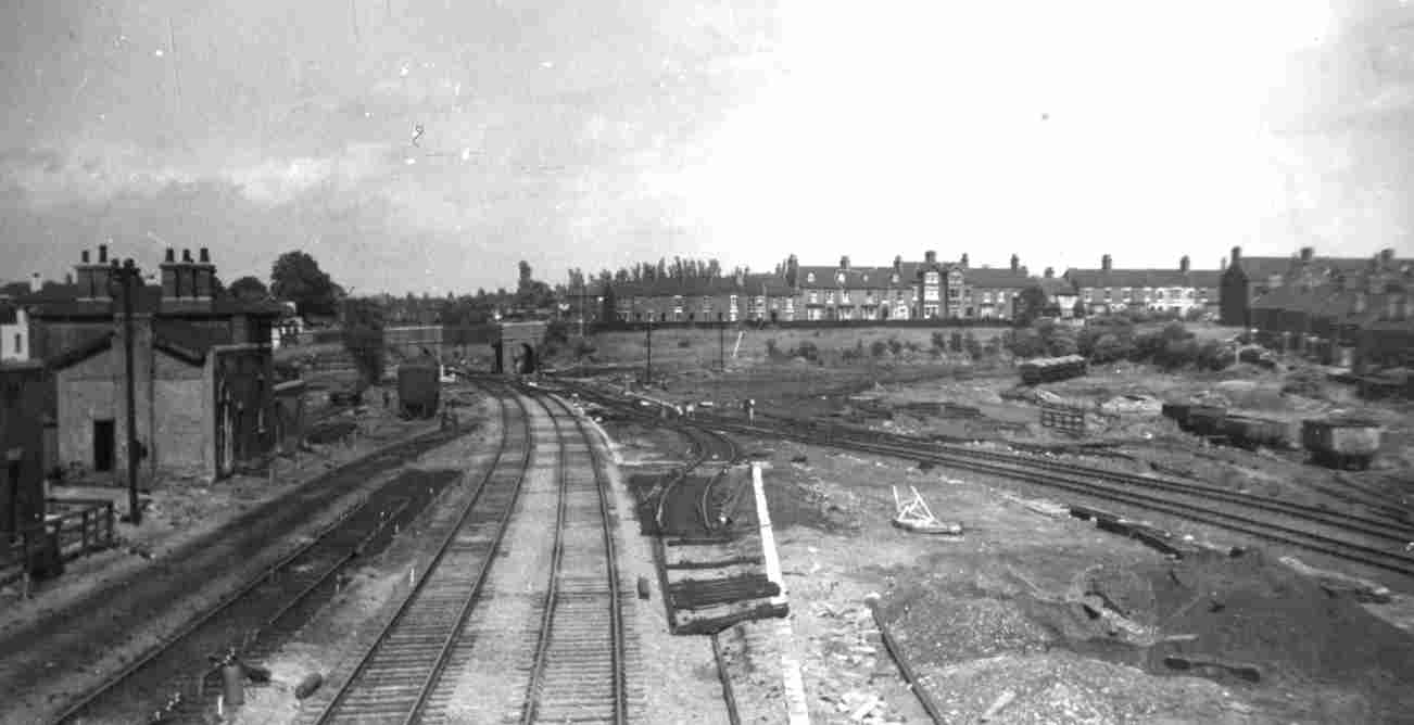
Standing on the concrete footbridge, the photographer takes a fascinating picture of the London road side and the new lines.
Note the two lines to the left that would have taken traffic up and over the flat-crossing, now disconnected.
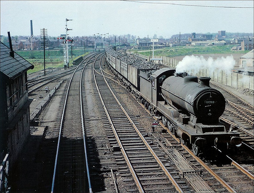
Pictured above is a steamer passing Thrumpton signalbox on the line to Lincoln, still showing the connection to the LNER before the dive-under was built. The box at this point was using mechanical signalling.
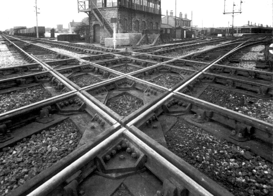
This picture shows what the work was all for; to remove the flat crossing which was becoming a bottleneck and restricting the speed of the expresses that would soon be dominating Retford. Now of course the iconic East Coast mainline.
The buildings to the right of the former Retford South signalbox is Network Rail offices today, which is where I am based.
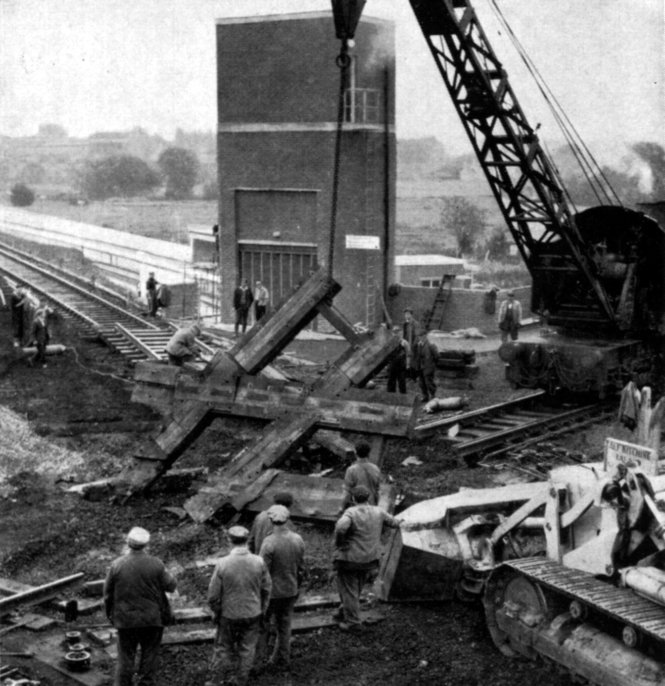
With the dive-under completed, the flat-crossing is removed on the 13th of June 1965 with a steam powered crane.
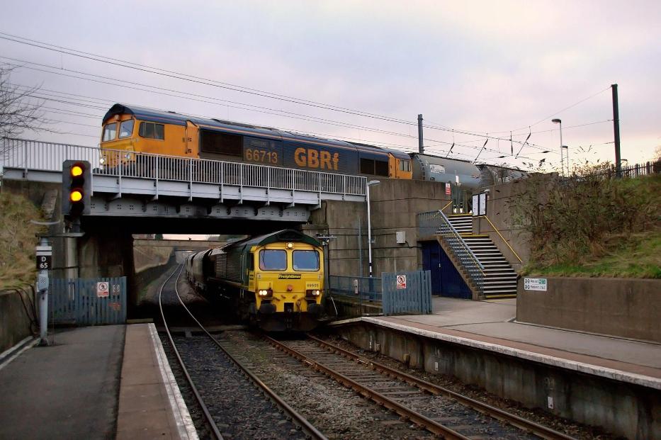
49 years after opening, and this is what it was built for; to allow the former Great Northern line to pass over the former Great Central line. This shot shows a freightliner on its way to either West Burton or Cottam power station and a GBRf freight passing above on the East Coast mainline going South towards London.
The flat crossing pictured above was just to the right of this picture.
Picture courtesy of Stephen Miller (via his dad John Miller).
These extracts give a good insight into just how big this engineering project was.
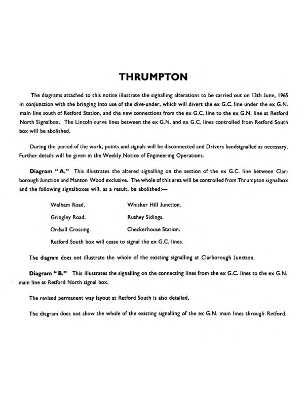
An extract from the 1965 signalling instruction to drivers and signallers detailing the work and subsequent closures.
A class 47 has just passed Mansfield Road level crossing and is on its way towards Worksop. The three tier bridge installed as part of the dive under can be seen in the background with a DMU just visible going up to the high level. The golfers footbridge dominates the skyline however.
The signalling has all changed and the signals seen (signals;T1 at yellow, T5 at red and D62 on the right) are now all gone following a £16m re-signalling scheme completed in 2013.
Picture courtesy of John Miller.
- Home
- About me
- Disclaimer and Copyright Information
- Contact Form
- Please sign the guest-book
- Signalbox area layout
- The Forum
- Links and Contributions
- The New Rail Innovation and Development Centre
- UK's first tram-train
- Signalbox Closure Dates
- Railway cable theft
- Railway Company Grouping
- The Beeching Report
- Anston
- Babworth
- Barnby Moor and Sutton Signalbox
- Bawtry
- Beckingham
- Beighton Station signalbox
- Beighton Train Depot
- Blyton
- Bolsover signalbox and station
- Botany Bay
- Boughton SB
- Brancliffe East Jn
- Brancliffe North
- Brigg Sidings SB
- Brookhouse
- Broughton Lane
- Brown Bayley's Sidings SB
- Canal Signalbox
- Catcliffe signalbox and station
- Checkerhouse signalbox
- Clarborough Jn
- Clipstone East
- Clipstone Sidings
- Clowne signalbox and Station
- Construction-of-Retford-dive-under 1963-to-65
- Cottam Station and Signalbox
- Darnall Signalbox
- Deepcar
- Dinnington Jn
- Dinnington North
- Edwinstowe Signalbox
- Egmanton
- Elmton and Creswell
- Firbeck A and B signalboxes
- Gainsborough Lea Road
- Gamston signalbox
- Gringley Road LC signalbox
- Grove Road
- Harworth Colliery
- Haxey
- High Marnham Signalbox
- Kirkby Summit
- Kirton Lindsey
- Kiveton Park Colliery SB
- Langwith Junction Signalboxes
- Leverton signalbox and station
- Lincoln Road
- Maltby North Junction
- Maltby station signalbox & Station
- Mansfield Concentration sidings
- Manton wood
- Misterton
- Ollerton signalbox
- Ollerton Station and Signalbox
- Ordsall Road Crossing
- Oxcroft Siding No3
- Pinxton Signalbox
- Ranskill
- Retford North and South signalboxes
- Rossington SB
- Rufford
- Rushey Sidings
- Scrooby Station and Signalbox
- Seymour Jn
- Shepcote Lane Junction
- Shirebrook Sidings
- Shirebrook South
- Shirebrook Station SB
- Shireoaks Colliery Sidings
- Shireoaks East Jn
- Shireoaks West Jn
- Sleights East
- Steetley Colliery Sidings
- Sturton SB Station
- Thonock Sidings
- Thrumpton old and new signalling
- Tickhill SB
- Tinsley junctions
- Tinsley East
- Tinsley West
- Tinsley Park SB
- Tinsley South signalbox & station
- Tinsley Marshalling Yard
- Tinsley Yard signalbox
- Tinsley Yard Information
- Treeton signalbox
- Tuxford Signalboxes
- Upper Portland
- Wadsley Bridge
- Walkeringham
- Warsop Jn
- Warsop Signalbox and Station
- Welbeck Colliery Jn
- Welham Yard SB
- West Burton
- West Tinsley signalbox and station
- Whisker Hill Junction
- Whitwell
- Woodburn Jn
- Woodend Jn
- Woodhouse East Junction
- Woodhouse West Junction
- Worksop Sidings
- Worksop West
- The Woodhead Route
- Victoria Station Sheffield
- Victoria Station Information page
- Yorkshire Main signalbox